Service Navigation
Search
IMproving Preparedness and RIsk maNagemenT for flash floods and debriS flow events
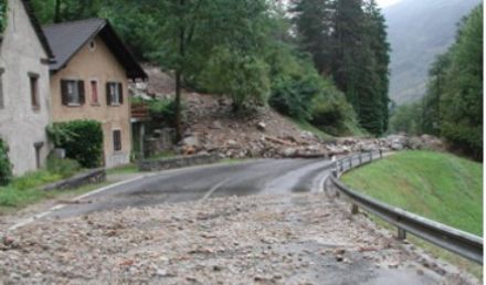
Flash floods and debris flows are usually the most devastating of all floods. They are localized phenomena that occur in small watersheds, leaving extremely short lead times for warnings. IMPRINTS is a European FP7 project (2009-2012) whose objective is to contribute to the reduction of loss of life and economic damage caused by flash floods and debris flows. The goal is to develop methods and tools for forecasting and warnings, to be used by practitioners of the emergency agencies and utility companies responsible for the management of these events. Three methodologies will be developed:
1. an early warning system
2. an integrated probabilistic forecasting system
3. a probabilistic rule-based forecasting system adapted to the operational use by practitioners
These system will be tested on five selected flash flood prone areas, two located in mountainous catchments in the Alps (Verzasca, Glarus), and three in Mediterranean catchments.
The high interdisciplinarity of the complex forecasting chain, covering meteorology, hydrology, geology, as well as risk management end-users, requires an international project team organized in ten Sub Projects.
MeteoSwiss participation
During intense precipitation events, meteorological and hydrological services, as well as emergency agencies need frequently updated short-term predictions of the intensity, location and development of rainfall. Nowcasting tools assume crucial importance in this context. The MeteoSwiss participation in IMPRINTS concentrates on the improvement of the short-term forecast of precipitation in the complex orography of the Alpine area, based on heuristic nowcasting systems. The research includes two main approaches, based mainly on weather radar observations with high spatial and temporal resolution:
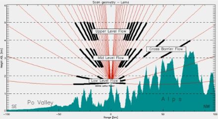
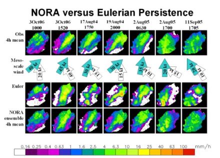
- Orographic forcing: An innovative, heuristic forecasting system for the nowcasting of orographic precipitation is being developed (Panziera et al., 2010). The NORA system is based on the relation between orographic precipitation, mesoscale winds (Figure 1: Vertical extension flows) and air mass stability (Panziera and Germann, 2010). To forecast precipitation fields the system uses the meteorological situations in the past (analogs) most similar to the current conditions, based on a number of predictors which have a strong relation to the orographic precipitation. The fully automated system ingests high-quality Doppler radar data and ground stations measurements for the computation of deterministic and probabilistic precipitation nowcasts in complex orography (Figure 2: Example of NORA precipitation forecasts).
- Lagrangian persistence: A second nowcasting system, MAPLE, which produces precipitation forecasts by using Lagrangian persistence of rainfall (Germann et al, 2006a), was successfully regionalized to the MeteoSwiss radar network domain. In a further step the system will be modified in order to consider the presence of the orographic forcing and how the orography influences the evolution of the precipitation, using a statistical approach.
- Combination of Lagrangian persistence with orographic forcing: In a final step the MAPLE and the NORA systems will be integrated, combining the Lagrangian persistence with the orographic forcing in order to produce reliable short-term predictions of rainfall.
The output of these nowcasting systems is used directly by the meteorological service of MeteoSwiss, by the emergency agencies, and will be ingested in real-time in a hydrological model for runoff forecasting.
This project is a natural continuation of the COST-731 project and it follows the strategic research line at MeteoSwiss on radar precipitation measurement in mountainous regions (Germann et al, 2006b, 2009) and nowcasting of thunderstorms in complex terrain (Hering et al., 2008), including interfaces to end-users in end-to-end forecasting systems like D-PHASE (Rotach et al., 2009).
2011
Panziera, L., U. Germann, M. Gabella and P. V. Mandapaka, 2011. NORA - Nowcasting of Orographic Rainfall by means of Analogues. Q. J. R. Meteorol. Soc. 137: 2106-2123.
Mandapaka, P.V., U. Germann, L. Panziera and A. Hering, 2011. Can Lagrangian Extrapolation of Radar Fields Be Used for Precipitation Nowcasting over Complex Alpine Orography?, Weather and Forecasting, 27: 28-49.
2010
Panziera L. and U. Germann, 2010: The relation between airflow and orographic precipitation on the southern side of the Alps as revealed by weather radar, Quart. J. Roy. Meteor. Soc., 136, 222-238.
2009
Germann, U., M. Berenguer, D. Sempere-Torres, and M. Zappa, 2009: REAL - Ensemble radar precipitation estimation for hydrology in a mountainous region. Quart. J. Roy. Meteor. Soc., 135, 445-456, doi:10.1002/qj.375.
Rotach M and co-authors: 2009, MAP D-PHASE - Real-Time Demonstration of Weather Forecast Quality in the Alpine Region, Bull Amer Meteor Soc, 90 (9), 1321-1336, DOI:10.1175/2009BAMS2776.1.
2008
Hering A, U Germann, M Boscacci, S Senesi, 2008: Operational nowcasting of thunderstorms in the Alps during MAP D-PHASE, Proceedings of the Fifth European Conference on Radar in Meteorology and Hydrology (ERAD), Helsinki.
2006
Germann U, I Zawadzki, B Turner, 2006a: Predictability of Precipitation from Continental Radar Images. Part IV: Limits to Prediction, J. Atmos. Sciences, 63, 2092-2108.
Germann, U., G. Galli, M. Boscacci, and M. Bolliger, 2006b: Radar precipitation measurement in a mountainous region. Quart. J. Roy. Meteor. Soc., 132, 1669-1692.