Service Navigation
Search
Implementation of an operational water vapor and aerosol LIDAR system
The RAman LIDAR for Meteorological Observation (RALMO) is an operational LIDAR system for continuous profiling of the water vapor mixing ratio, the temperature and the aerosol backscattering properties. The LIDAR development and installation at the MeteoSwiss station of Payerne has been co-funded by MeteoSwiss (54%), the Swiss Federal Institute of Technology in Lausanne, EPFL, (39%) and the Swiss National Science Foundation (7%). The RALMO system is fully automated and runs on an operational basis since the year 2008. The water vapor product has been extensively validated against operational radiosonds (Brocard et al., 2013).
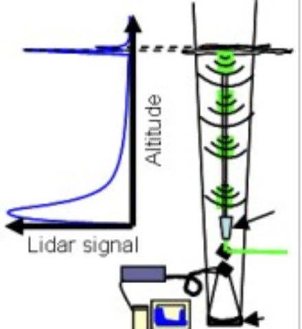
The MeteoSwiss-EPFL LIDAR supplies data with high vertical (3.75 m for raw data) and temporal (~60 sec for raw data) resolution, thus helping to improve the database for direct meteorological applications by adding real time water vapor, temperature and aerosol optical properties profiling. The interested reader is referred to Dinoev et al., 2013 for more technical details. RALMO provides MeteoSwiss and EPFL with a database of great importance for climate change modelling and trend analysis in aerosol and water vapor content in the troposphere. The RALMO humidity profiles are also part of GRUAN (GCOS Reference Upper-Air Network) and NDACC (Network for Detection of Atmospheric Composition Change) database for climatological and reference measurements. The aerosol optical properties are part of the EARLINET (European Aerosol Research Lidar Network) to contribute establishing a European-scale aerosol climatology.
Moreover, LIDAR information together with conventional data are applied for comparison, validation and further development of the prognostic model COSMO.
LIDAR’s site of installation
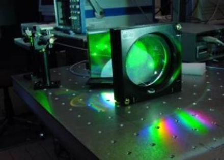
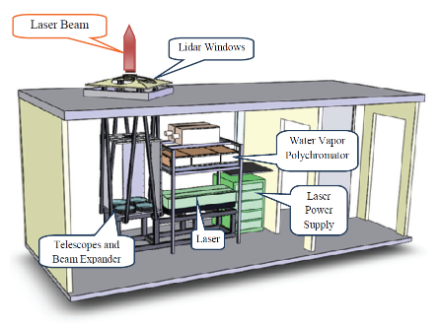
The system is installed in a cabin, divided into two distinct rooms: a "white" room containing the system itself, with an automatic opening/closing roof allowing the LIDAR beam to be emitted through the ceiling and the backscattered light to be collected, and a computer room, from which the system is operated (see Figure 1).
Results
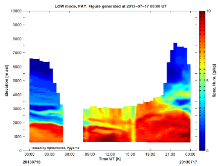
Recent LIDAR data are shown in timeseries of vertical profile of water vapor displaying the multi-layer vertical structure of the boundary layer on the 12th of July 2013 (Figure 2). Nocturnal measurements of the water vapor are of higher quality due to the reduced background noise and so the profiles are calculated up to 9-10 km.
The LIDAR ceilometer CHM15K
The CHM15K ceilometer (Flentje et al., 2012; Milroy et al., 2012; Wiegner and Geiss, 2012) uses a laser source which is a diode-pumped Nd-YAG laser (1064 nm) yielding about 8 μJ per pulse at 5–7 KHz repetition rate. It measures atmospheric target backscatter profiles over the nominal range 0.03–15 km with first overlap point at 30 m and ~1500 full overlap. In the operating range of 15 kilometers it can reliably detect lower cloud layers as well as cirrus clouds although the latter can be hidden in the noisy component of the signal during daytime hours. The highest vertical resolution at which the instrument can work is 15 m with measured full vertical profiles of aerosol backscatter and detected cloud height, boundary layer height, and visibility values. The measuring principle is LIDAR-based with photon-counting detection system.
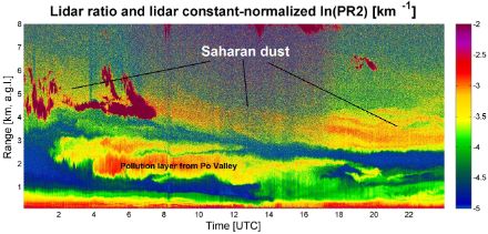
The CHM15K backscatter data are processed in order to provide real-time information about geometrical and optical properties of different types of aerosol layers. As part of the EUMETNET programme E-PROFILE (http://www.eumetnet.eu/e-profile) real-time profiles of extinction/backscatter coefficient will start to be provided in late 2014. An example of range-corrected data on a day characterized by a complex layer structure in the lower Troposphere, is provided in Figure 3. Two different layers were advected from the Po Valley in Northern Italy (lower layer) and the Saharan region (upper layer) on the 30th of March 2014.
Raman Lidar for Meteorological Observations, RALMO – Part 1: Instrument description
T. Dinoev, V. Simeonov, Y. Arshinov, S. Bobrovnikov, P. Ristori, B. Calpini, M. Parlange, and H. van den Bergh Atmos. Meas. Tech., 6, 1329-1346, 2013
Raman Lidar for Meteorological Observations, RALMO – Part 2: Validation of water vapor measurements E. Brocard, R. Philipona, A. Haefele, G. Romanens, A. Mueller, D. Ruffieux, V. Simeonov, and B. Calpini Atmos. Meas. Tech., 6, 1347-1358, 2013
M. Wiegner and A. Geiß (2012): Aerosol profiling with the JenOptik ceilometer CHM15kx, Atmos.
Meas. Tech. Discuss., 5, 3395–3430, doi:10.5194/amtd-5-3395-2012
Raman Frequency Shifting in CH4 :H2 :Ar mixture pumped by the 4th Harmonic of Nd :YAG (V. Simeonov, V. Mitev, H. van den Bergh, and B. Calpini) Appl. Opt., Vol 37, No 30, pp 7112-7115, 1998.
A Raman Differential Absorption Lidar for Ozone and Water Vapor Measurement in the Lower Troposphere (B. Lazzarotto, V. Simeonov, P. Quaglia G. Larchevêque, H. van den Bergh, and B. Calpini) Int. J. Env. Analytical Chem., 74, pp255-261, 1999
Experimental investigation of high-power single-pass Raman shifters in the ultraviolet with Nd :YAG and KrF lasers (L. Schoulepnikoff, V. Mitev, V. Simeonov, B. Calpini, and H. van den Bergh) Appl. Opt., Vol 36, No 21 pp 5026-5043, 1997.
Water vapor Upper Air Observations at MeteoSwiss Payerne Bertrand Calpini 1, Vincent Hentsch 1, Pierre Huguenin1, Dominique Ruffieux 1, Todor Dinoev 2, Valentin Simeonov 2 ISTP2009, Delft
Ext_abstract_Calpini_ISTP_2009vf.pdf, 418 KB
Aerosol profiling using the ceilometer 10 network of the German meteorological service. ( H. Flentje, B. Heese, J. Reichardt, and W. Thomas), AtmosphericMeasurement Techniques, vol. 3, pp. 3643–3673, 2010.
An Assessment of Pseudo-Operational Ground-Based Light Detection and Ranging Sensors to Determine the Boundary-Layer Structure in the Coastal Atmosphere. (Milroy, C., G. Martucci, S. Lolli, S. Loaec, L. Sauvage, I. Xueref -Remy, Jost V. Lavric, P. Ciais, Colin D. O’Dowd) Advances in Meteorology, 2012, ID 929080, 18 pages. doi:10.1155/2012/929080
Contacts
MeteoSwiss: Dr. Giovanni Martucci, Dr. Alexander Haefele.
EPFL: Dr. Valentin Simeonov EPFL ENAC ISTE LPAS, CH C2 392, Station 6, CH-1015 Lausanne
MeteoSwiss: Prof. Bertrand Calpini, project leader.