Service Navigation
Search
LIDAR devices send laser beams into the atmosphere, where they react with molecules and particles. Part of the radiation is reflected back to the surface of the Earth, where it can be collected and analysed. This allows the level of humidity, the temperature and the dispersal properties of aerosols to be derived. MeteoSwiss operates two different types of LIDAR instruments at the aerological station in Payerne. Humidity, temperature and aerosol profiles are created using a so-called Raman LIDAR. Ceilometers (elastic backscattering LIDARs), which provide aerosol profiles, are also used.
Raman LIDAR: water vapour, temperature and aerosol profiles
The Raman LIDAR is an operational LIDAR system which continually measures profiles for the water vapour mixing ratio, temperature and aerosol dispersal properties. The system's full name is RALMO (Raman LIDAR for Meteorological Observation). The development of the LIDAR and its installation in Payerne was made possible thanks to the cooperation between MeteoSwiss, the Swiss Federal Institute of Technology in Lausanne (EPFL) and the Swiss National Science Foundation (SNF). The RALMO system has been in operation since 2008 and runs fully automatically. The water vapour product has been extensively compared with radiosondes and thus validated.

The LIDAR provides data with a high level of resolution (vertical: 3.75 metres, temporal: around 60 seconds). The real-time profiles for water vapour, temperature and optical aerosol properties feed into the MeteoSwiss data warehouse. The LIDAR measurements are important for the modelling of climate change and for analyses of water vapour and aerosol concentration trends in the troposphere.
The RALMO humidity observations feed into the climatological and reference measurements databases of GRUAN (GCOS Reference Upper-Air Network) and the NDACC (Network for Detection of Atmospheric Composition Change). The measurements of optical aerosol properties also support EARLINET (European Aerosol Research Lidar Network) and the establishment of a European-wide climatology of aerosols. Information from the LIDAR is also used together with conventional data in order to validate and further develop the COSMO forecasting model.
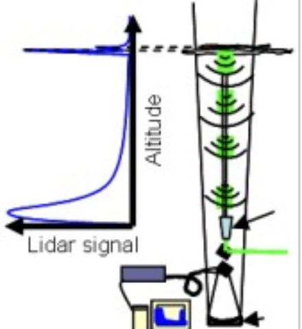
The operation of RALMO
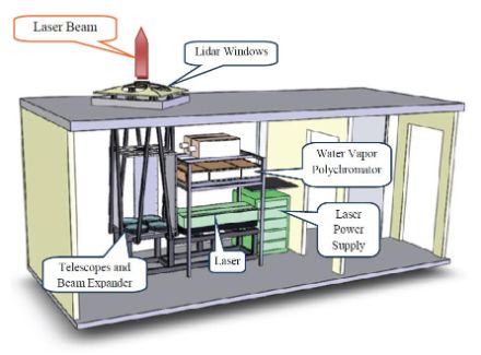
The system is installed in a cabin with two rooms, with the LIDAR system being housed in the first. The laser beam is emitted through a special window in the ceiling. The backscattered light reaches the telescope through several windows and is then registered. The computers which operate the system are located in the second room. The operation of the LIDAR is automatically broken off in the event of rain or low cloud.
Results from RALMO
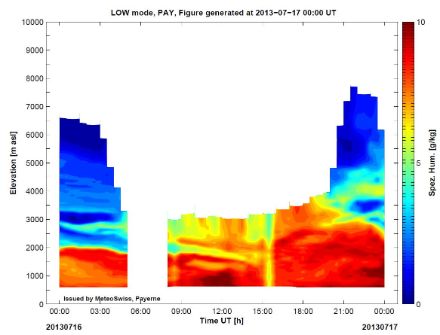
LIDAR data is presented as a time series of vertical water vapour profiles. The large variability of the water vapour is thus clearly identifiable. At night, water vapour measurements are possible up to an altitude of 10 kilometres. During the day, the strong solar radiation limits the measurement range to 4 kilometres.
The LIDAR ceilometer CHM15K
MeteoSwiss also uses CHM15K ceilometers to measure aerosol profiles. It also uses a laser source. Backscattering profiles are measured at altitudes between 0.03 and 15 kilometres above the ground with a vertical resolution of 15 metres. The device reliably identifies lower cloud levels and cirrus clouds at a range of up to 15 kilometres. In addition to the cloud base, information on aerosols, the boundary layer height and visibility are also determined. Real-time information on the geometric and optical properties of the various aerosol layers is generated using the backscatter data from the CHM15K. The ceilometers are part of the E-PROFILE European ceilometer network of EUMETNET.
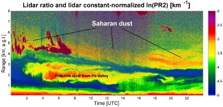
The complex layering of the lower troposphere on 30 March 2014 can be seen in the graphic below. On this day, two different air layers were transported into Switzerland. In a layer between 4 and 6 kilometres, sand from the Sahara region can be seen, sinking during the course of the day. At an altitude of between 1.5 and 3 kilometres, contaminated air can be identified (marked in red and yellow) which was carried to Switzerland from the Po Valley in northern Italy.
- Raman Lidar for Meteorological Observations, RALMO – Part 1: Instrument description
T. Dinoev, V. Simeonov, Y. Arshinov, S. Bobrovnikov, P. Ristori, B. Calpini, M. Parlange, and H. van den Bergh Atmos. Meas. Tech., 6, 1329-1346, 2013 - Raman Lidar for Meteorological Observations, RALMO – Part 2: Validation of water vapor measurements E. Brocard, R. Philipona, A. Haefele, G. Romanens, A. Mueller, D. Ruffieux, V. Simeonov, and B. Calpini Atmos. Meas. Tech., 6, 1347-1358, 2013
- M. Wiegner and A. Geiß (2012): Aerosol profiling with the JenOptik ceilometer CHM15kx, Atmos. Meas. Tech. Discuss., 5, 3395–3430, doi:10.5194/amtd-5-3395-2012
- Raman Frequency Shifting in CH4 :H2 :Ar mixture pumped by the 4th Harmonic of Nd :YAG (V. Simeonov, V. Mitev, H. van den Bergh, and B. Calpini) Appl. Opt., Vol 37, No 30, pp 7112-7115, 1998.
- A Raman Differential Absorption Lidar for Ozone and Water Vapor Measurement in the Lower Troposphere (B. Lazzarotto, V. Simeonov, P. Quaglia G. Larchevêque, H. van den Bergh, and B. Calpini) Int. J. Env. Analytical Chem., 74, pp255-261, 1999
- Experimental investigation of high-power single-pass Raman shifters in the ultraviolet with Nd :YAG and KrF lasers (L. Schoulepnikoff, V. Mitev, V. Simeonov, B. Calpini, and H. van den Bergh) Appl. Opt., Vol 36, No 21 pp 5026-5043, 1997.
- Aerosol profiling using the ceilometer 10 network of the German meteorological service. ( H. Flentje, B. Heese, J. Reichardt, and W. Thomas), Atmospheric Measurement Techniques, vol. 3, pp. 3643–3673, 2010.
- An Assessment of Pseudo-Operational Ground-Based Light Detection and Ranging Sensors to Determine the Boundary-Layer Structure in the Coastal Atmosphere. (Milroy, C., G. Martucci, S. Lolli, S. Loaec, L. Sauvage, I. Xueref -Remy, Jost V. Lavric, P. Ciais, Colin D. O’Dowd) Advances in Meteorology, 2012, ID 929080, 18 pages. doi:10.1155/2012/929080